What type of holiday are you looking for? Are you traveling with family or friends? When would you like to visit? Let us make some recommendations!


Scaling 2,393 m (7,851 ft), this limestone mountain is home to a popular yet very difficult hiking trail.
Mount Proctor is an all-day intensive hike allowing adventurers to enjoy a full day hike through an array of landscapes and habitats. Dog are not allowed on this trail.
Difficulty Level: ![]()
![]() Very difficult - steep sections, rocky sections, scrambling
Very difficult - steep sections, rocky sections, scrambling
Elev. Gain: 1,500m
Average Time: 8-11 hrs round trip
Length: 20km loop
IMPORTANT: Be prepared with proper hiking boots, lots of water and food. Having hiking poles is helpful. Fernie has many outdoor gear shops. Know what to expect for weather and dress accordingly, temperatures are cooler the higher in elevation you go. Tell someone you know where you are going and when you plan to be back in case you run into any issues. This is bear country, learn about being safe in the mountains and carry bear spray and know how to use it (WildsafeBC). Pack in, pack out. Don't leave any garbage behind. If you have a dog and it poops on the trail, use a stick to push it fully off the trail or bag it and pack it out (same with human poop). There are no toilets at the trailhead or on the trail, if you use toilet paper pack it out or bury it in the ground off the trail. To learn more about adventuring safely visit AdventureSmart.
There are no services or specific camping areas along this trail. 'Leave No Trace' backcountry wilderness tenting is permitted. Be prepared for backcountry hiking, wildlife and weather changes. There could still be snow at higher elevations, even into July.
Stop and park at the Fernie Chamber of Commerce & Visitor Information Centre on Highway #3 just east of town. Toilet facilities, bins, and water is available inside the centre which is open in summer 9am-5pm daily. When closed there is a toilet at the end of the parking lot. The trail starts by the big trail map sign, follow the trail markers for Mt Proctor Hike.
You can pick up a Fernie Trail Map before your hike at the Visitor Centre or click on the link to view a PDF. The Trailforks app is a great GPS based map for your mobile where can track progress and your location along this hike. There is limited to zero cellular service beyond the 4km mark but your GPS function on your phone would still work without cellular if you've downloaded Trailforks and the local map ahead of time.
Depending on the winter snowfall, this hike may not be snow-free until mid to late-July. Route finding may be required if snow is covering the trail.
This challenging all-day high mountain adventure hike reaches the summit of Mt. Proctor at 2390m and should be started in the early morning. Mount Proctor is an intensive trail allowing hikers to enjoy a full day hike through an array of habitats. This loop trail can be hiked in either direction, however the scrambling section is best done going up versus going down it which means taking the trail in a counter-clockwise direction. It's highly recommended to hike this trail in a counter-clockwise direction starting at the Fernie Visitor Information Centre. Please be aware that this trail passes into private grazing area for cattle, and that dogs are unfortunately not permitted on this trail due to the safety of livestock.
In the counter-closewise direction the first section of the trail departs from the Fernie Visitor Information Centre via a gentle climb then connects with Swine Flu trail. Be aware there may be a few cows grazing in this lower section of the trail, as well as mountain bikers riding slowly up the trail. Follow the trail signs for Mt Proctor Trail and continue to the Swine Flu Bench. This is a great rest stop and where you'll be rewarded with a spectacular view across Fernie. After a short rest at the bench, the Mt Proctor Trail continues up from the bench. There is another trail that heads down from the bench which is the downhill trail for the mountain bikers.
With each switchback, the trees will gradually thin out as you ascend through the subalpine zone. You'll be following alongside the ridgeline high up on your right side as you move towards Mount Proctor's summit. The final approach to the peak will be rocky, loose and shaley and will require some scrambling.
Have a long and well-deserved break at the summit and lunch at the picnic bench. The climb is all done.
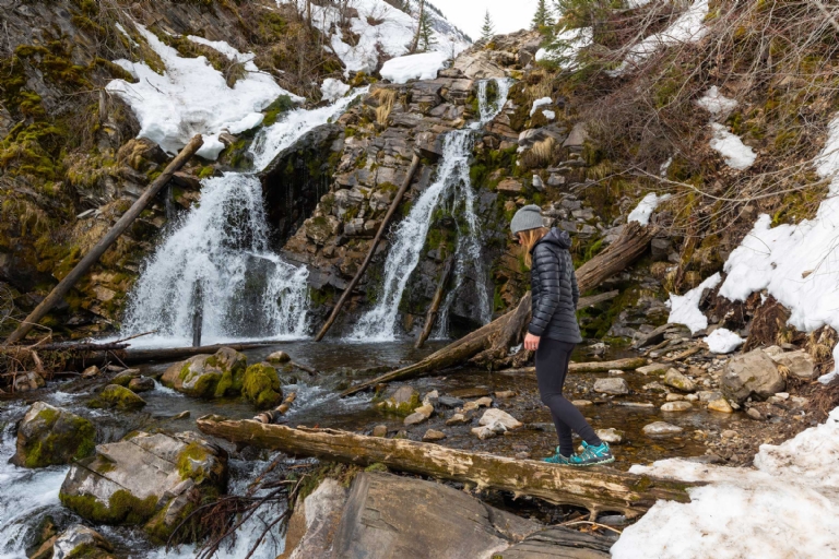
From the summit, continue following the trail north along the ridge. The descent down into the valley between the Three Sisters and the back of Mount Proctor is loose and rocky. Signs and cairns will line the trail. A tarn, an alpine lake, is accessible from the trail and can be a great spot to cool off. This lake can dry up late in the season if the summer was long and hot. You'll eventually connect with the Upper Fairy Creek Falls where you'll find a picnic bench viewpoint. From here, you'l head down to the main Fairy Creek Falls and it's a gentle hike back towards the Fernie Visitor Centre.
Trail conditions reports are powered by TrailForks app through information contributed by local and visiting hikers. Please feel free to add and update the trail report if you have completed the hike recently.