
Fernie Ridge Trail
The Fernie Ridge Trail (also known as Heaven's Gate) offers a challenging but beautiful hike weaving through treeline and sandstone cliffs into panoramic views from atop Fernie Ridge.
Fernie Ridge Trail
The Fernie Ridge Trail (also known as Heaven's Gate) offers a challenging but beautiful hike weaving through treeline and sandstone cliffs into panoramic views from atop Fernie Ridge.
Fernie Ridge Trail
The Fernie Ridge Trail (also known as Heaven's Gate) offers a challenging but beautiful hike weaving through treeline and sandstone cliffs into panoramic views from atop Fernie Ridge.
Fernie Ridge Trail
The Fernie Ridge Trail (also known as Heaven's Gate) offers a challenging but beautiful hike weaving through treeline and sandstone cliffs into panoramic views from atop Fernie Ridge.


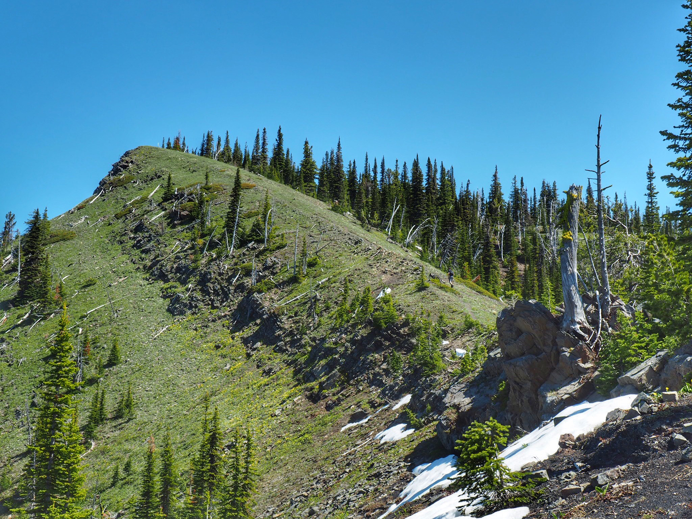
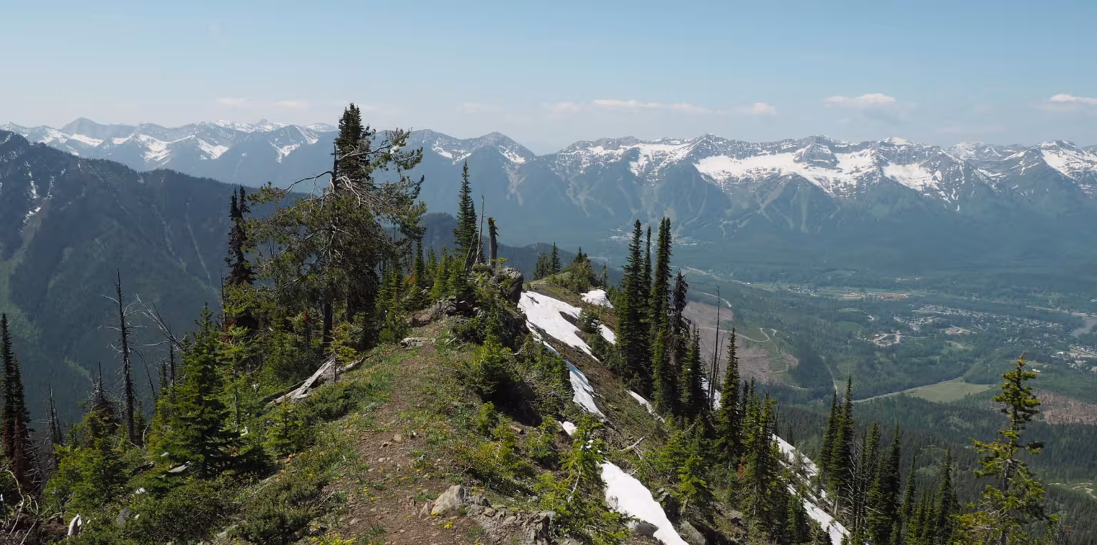
The Fernie Ridge Trail is on the southeast side of Fernie above the Ridgemont area. The trail weaves through the treeline up and over sandstone rock onto the cliffs of Fernie Ridge. On a clear day, you'll have views of all the neighbouring mountains surrounding Fernie.
Fernie Ridge Trail
Difficulty Level: Difficult
Hiking Time: 4 hours round trip
Distance: 3.2km to peak
Elevation Gain: 721 metres
Fernie Ridge Trail: What to Know
Head east along Coal Creek Road for approximately 2 km until you reach Rifle Range Road on your left side. The climb up can be challenging and a vehicle with 4x4 capabilities and high clearance is highly recommended. Continue up the road taking a right turn at the first fork, followed by a left at the second fork.
At the next junction follow the switchback to the right, (almost a 180-degree turn). Continue along the road past the trailhead for Contra until you see a right-hand turn in a clear-cut that is impassable by vehicle. Park your vehicle just further ahead to the side.
On foot, continue up the inaccessible road following the cairns (man-made stone mounds) marked with orange flagging tape.
This trail is considered difficult.
The hike begins with a short and steady climb through a logged clearing until you reach the treeline. From here, the trail begins to switchback under the subalpine trees as the pitch will increase. The route becomes a little loose, rocky, and exposed leading to the final stretch up to the ridge. There is no water along this hike.
The Fernie Ridge trail is best accessed from June until November. Depending on the winter snowfall amounts, Fernie Ridge tends to be accessible starting mid-June. Expect some small amounts of snow, particularly in the shaded, treed areas on the way up. Beyond the ascent up the spine to the ridge top you may encounter deeper snow before early-July.
Yes, dogs are allowed on Fernie Ridge trail, however they should be kept on leash and under control, especially with wildlife in the area.
Please make sure to pick up and clean up after your dog, and don't leave the bags along the trail. Please note that there aren't any garbage bins or facilities located at the trailhead. There is no water available along the trail either.
Fernie is within the bear & wildlife country, so it’s always good to be prepared. Carry bear spray (and know how to use it), make noise, and stay aware of your surroundings. You can buy bear bells at the Visitor Centre. Bear spray can be purchased at Canadian Tire or some of the bike shops in town.
As with any trip into nature, be well prepared for changes in weather. Remember that you are travelling in an area where wildlife is abundant. Be aware of your surrounding, be loud, follow the proper safety protocols and respect the environment.
Latest Trail Conditions
Trail conditions reports are powered by the TrailForks app through information contributed by local and visiting hikers. Please feel free to add and update the trail report if you have completed the hike recently.