


During the spring and summer, we monitor regional conditions and share occasional updates relevant to Fernie, including air quality and nearby environmental activity.
Fernie is part of the South East Fire Centre region.
As of July 22, 2026:
- There are no wildfires in Fernie area.
- Today's skies are hazy from wildfires in NW US, NW Territories, and around Cranbrook/Kimberley. The closest fire is near Skookumchuk on Hwy #93 and under control, about 40km northwest as the crow flies.
- Campfires (category 1) are banned, effective THURSDAY, JULY 23, 2026. Read Details.
- Category 2 and Category 3 open fires are prohibited! See official website for details.
Fernie Sky Watch
Latest images of Fernie's sky and visibility.
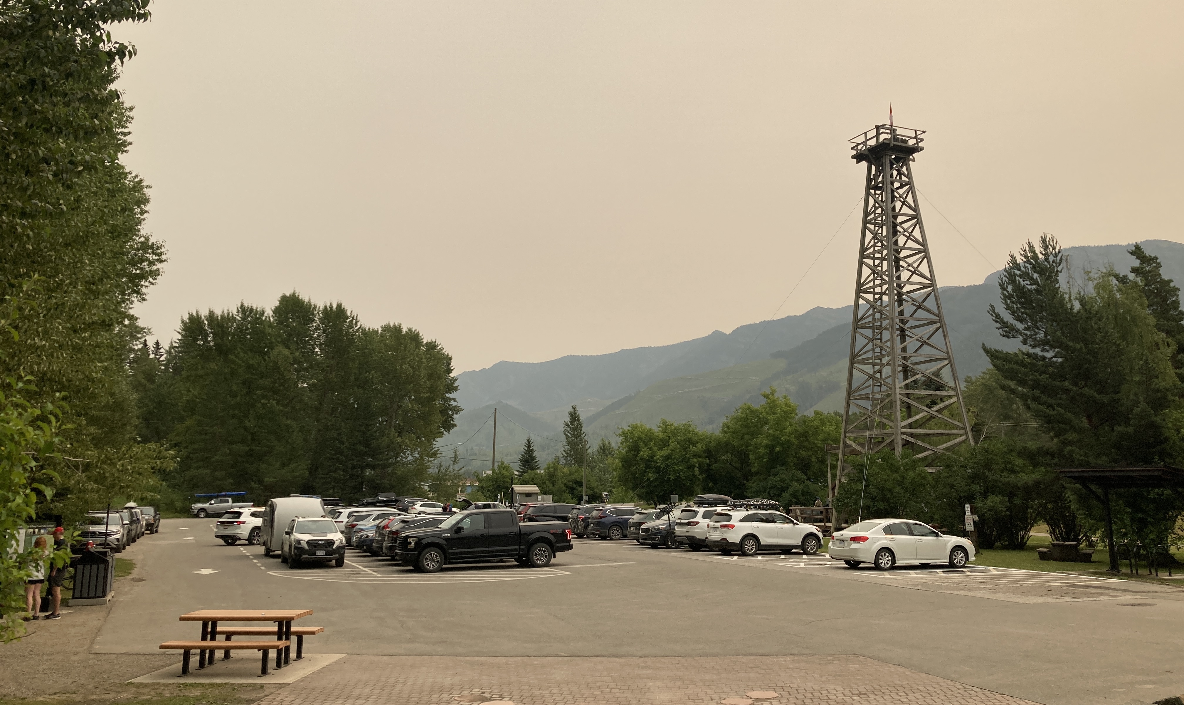
July 21, 2026 at 8:50 am looking S
July 20, 2026 at 8:15 am looking NW
July 16, 2026 at 8:50 am looking NW
July 13, 2026 at 10:00 am looking S
July 9, 2026 @12:26pm looking W.
July 2, 2026 at 8:30am looking NW.
June 18, 2026 looking SW.
What to do if you see signs of a wildfire? Call!
To report a fire or smoke plume, call *5555 or 1-800-663-5555
What is the current air quality like in Fernie?
Closest air quality monitoring is in Sparwood, 20km away and in Cranbrook, 95km away. Fernie regularly has a clearer sky than Cranbrook and Sparwood, due to the proximity of any BC wildfires and prevailing winds. For local 'on-the-ground' information please call the visitor centre in Fernie (open daily 9am-5pm) at 778-519-0748 BC Air Quality Map
An air quality station located in Sparwood (30km away) readings can be found on IQAir. A Purple Air Monitor provides real-time air quality readings for Fernie on 'Purple Air'. Pollen Count information can also be found on IQAir.
Is there any flooding in Fernie?
Fernie rarely experiences flooding. For Flood Watch Updates and extreme weather notices, please see the City of Fernie's latest news updates.
Important Links
- BC Map showing locations of wildfires - Fernie is in the South East region
- Regional wildfires and alerts - Regional District of East Kootenay
- Local weather forecast & climate details
- Smoky sky? Smoke forecast map
- Local Realtime webcams
- BC Air Quality Map - Closest air quality monitoring is in Cranbrook, 95km away. Fernie regularly has a clearer sky than Cranbrook due to the proximity of any BC wildfires and prevailing winds.
- HWY 3 - BC Highway & Road Reports
- BC campfires & fireworks ban information
Local radio stations
- The Drive/Rewind Radio 102.9 FM (Fernie/Cranbrook)
- B104/The Wild 104.7 FM (Fernie/Cranbrook)
- Summit/2DayFM 107.9 FM (Cranbrook)
- CBC Radio 97.7 FM (Kelowna)
Additional links
- RDEK Facebook - when there are wildfires in the region, updates are provided here. Managed by the regional government for residents.
- EmergencyInfoBC
- Alberta Wildfires
- In case of emergency
- Additional Air Quality Information Sources:
- Smoke in the Skies - forecasting & tracking
- BC Air Quality Advisories - Fernie is located in the East Kootenays/Elk Valley
- BC Air Quality Health Index
Past Summer Conditions
The previous six summers saw no forest wildfire activity in our immediate area. Fernie can experience periodic smokey skies, primarily between late July and early September due to winds pushing smoke in from wildfires far away.
In BC, local community and regional governments lead the initial response to emergencies in communities.
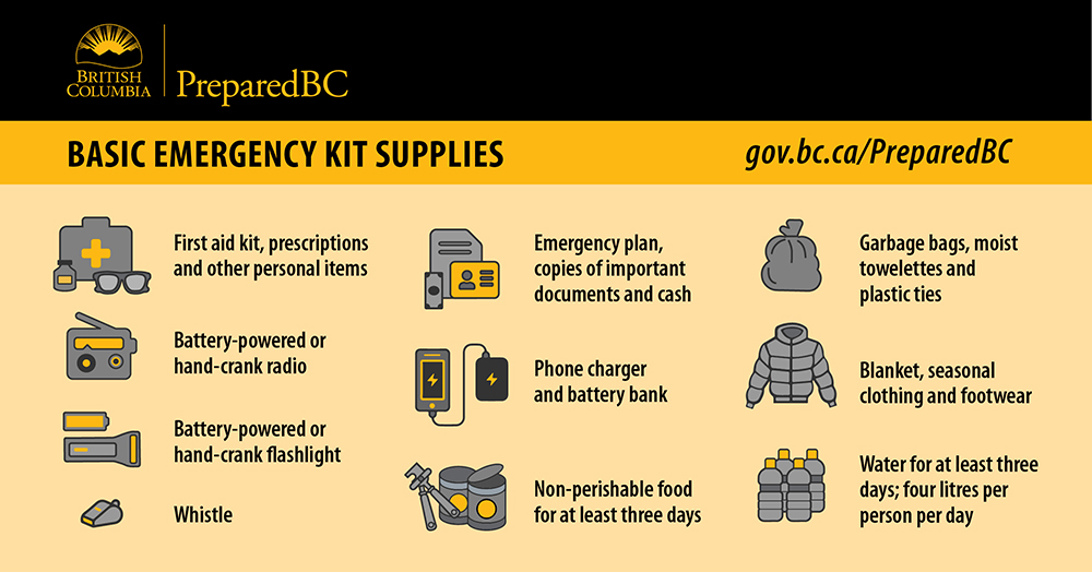
How to Prepare in Case of Wildfire
Wildfire Preparedness - What To Do. In BC, local community and regional governments lead the initial response to emergencies in communities.