
Heiko's Trail
This is one of Fernie's most beloved big alpine wilderness hikes. Do the classic 20 km hike or choose from other long or short options.
Heiko's Trail
This is one of Fernie's most beloved big alpine wilderness hikes. Do the classic 20 km hike or choose from other long or short options.
Heiko's Trail
This is one of Fernie's most beloved big alpine wilderness hikes. Do the classic 20 km hike or choose from other long or short options.
Heiko's Trail
This is one of Fernie's most beloved big alpine wilderness hikes. Do the classic 20 km hike or choose from other long or short options.


Finished in 2003, the classic 20km Heiko’s Trail to Island Lake Lodge was built by one of Fernie’s renowned residents, Heiko Socher. He moved here as a forestry manager in 1964, and was integral in the early development of Fernie Alpine Resort. Originally named Mountain Lakes Trail, the trail was officially renamed to Heiko's Trail after the passing of Heiko in 2016. He was very active in the community so much that everyone knows the name and much of his legacy.
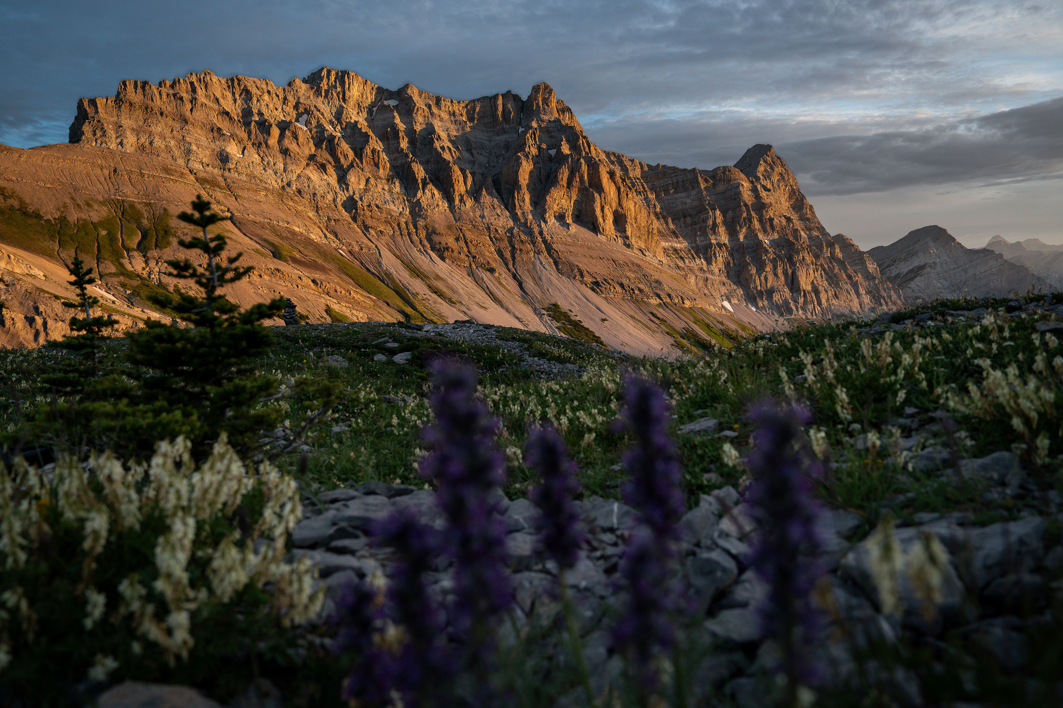
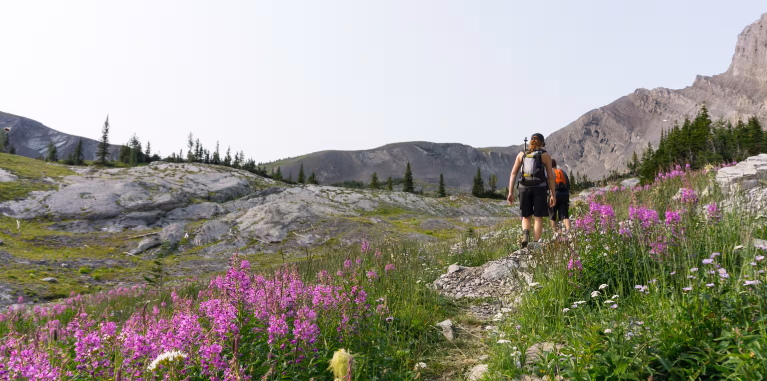
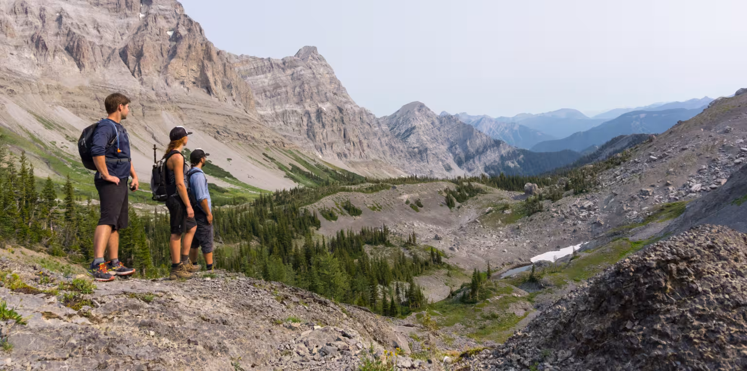
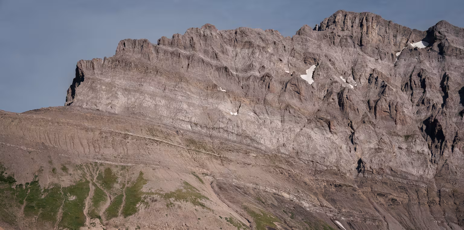
Heiko's Trail is in a backcountry wilderness area with abundant wildlife, and some of the most spectacular scenery in the Rockies. There is no cell phone coverage. This area contains a network of trails that run through a spectacular alpine environment with many unique features. You will enjoy exploring cascades, waterfalls, a large cave, a rugged creek canyon and jagged peaks towering above expansive alpine meadows. These trails are designated for hiking and non-motorized use only, no bicycles or off-road vehicles are permitted. All the trails in this area are difficult and require wilderness hiking attire and preparedness. High level of fitness and some basic route-finding skills required.
Road access requires high clearance vehicles along forestry/dirt/gravel roads. Carrying a GPS communication device is highly recommended. Dogs on leash and under control are allowed on the trail, you must clean up after them. Remember, this is a wildlife country, and we are just visiting. Help us protect this precious piece of wilderness.
Trail Maps
- See PDF overview of the Heiko's Trail network
- For online GPS maps: download the Trailforks App along with the GPS on your cell phone (download the trail before you go when you have wifi/data as there is no wifi or data on the trail). Your cell phone GPS works without data as long as you have battery power and the app and maps installed.
Topographic Maps
- These topo maps do not show the trail specifically, but provide detailed geo map data on elevations, passes, valleys, and more to help understand the terrain. Download Map #'s 082G065 & 082G055.
- All BC topo maps
When can you hike Heiko's Trail?
Due to the elevation and slope aspect of this trail, it usually takes a while for Heiko's to become fully accessible. An average guideline time is around late June to early September, but this varies depending on the winter snowfall and spring thaw. You can find trail conditions and status by connecting with locals and see if there are any updates via Trailforks online.
One-way Route Options
See return / out & back hiking options futher below
Classic Heiko's Trail to/from Island Lake Lodge
Difficulty Level: Difficult
Hiking Time: 8-11 hours
Distance: 20km one-way
Elevation Gain: 1,450 metres
Elevation Loss: 1,585 metres
Access (start or finish) via Island Lake Lodge is available only on certain operational days. When planning, check the Island Lake Lodge's operations calendar online or call them directly at 250-423-3700. Otherwise, add an additional 7km to the hike using Lazy Lizard Trail to Mt Fernie Provincial Park.
Driving to Heiko's Trailhead - it is highly beneficial to use Trailforks App on your GPS enabled mobile device to help you find the way. Access road needs high clearance vehicle. Drive 5.3 kilometres east on Hwy 3 from Fernie and turn left onto Dicken Road, continue about 600m then turn right up Hartley Lake Road, and drive another 15 kilometres on this windy, rough dirt road that climbs past Hartley Lake Recreation Site. Continue on this road and just after your second left you will see a trail marker post. Turn left, it is recommended that you park at the first lot and hike the 2.5 km to the main trailhead (it can take as long to hike it as it does to drive it). If you have knowledge of driving rough backcountry roads and have a 4x4 vehicle with high clearance, you may continue on a further 2.5km to the last parking lot/main trailhead, note that this section of narrow backcountry dirt road is rutted with some over-grown shrubs and trees. The shrubs on this section of old rough road can scratch your vehicle. There is a large trail sign at the second lot, where Heiko's Trail formally starts. There is a pit toilet at the trailhead.
Hike Details
Follow a well-defined trail through alpine meadows, the iconic points of interest and over two distinct mountain passes with spectacular Rocky Mountain views. Just over 6km into the hike is the designated camping area for those overnighting, with bear hang for food and a designated cooking area.
At Three Sisters Trail junction stay right to continue 1 km to Three Sisters Pass. At Three Sisters Pass you’ll stay right and continue for 5 km towards Windy Pass. At Windy Pass you’ll stay right and continue for 3 km towards Tamarack Trail, which is one of Island Lake Lodge’s hiking trails. Take this 3.1 km trail down to the junction with Lazy Lizard Trail, take this final gentle trail west for the final 1 km to the Lodge.
This route option represents the classic version above but in the opposite direction.
Driving to Island Lake Lodge - Head southwest out of Fernie on Hwy 3. Turn right at the Mt Fernie Park Road at the signs for Mt Fernie Provincial Park and Island Lake Lodge across the hwy from the Stanford Hotel. Continue on this road through the Provincial Park and on the dirt road until you reach Island Lake Lodge first entrance and gate. Staff may be on site to greet you and confirm access to the Lodge area approximately 7 km further up the road. The lodge has washrooms if open. When planning, check the Island Lake Lodge's operations calendar online or call them directly at 250-423-3700.
Hike Details
Follow the Tamarack Trail from the Lodge, just over 3 km up until it connects to Heiko's Trail, continue and additional 3km up to Windy Pass, then 5 km to Three Sisters Pass. A further 1 km down brings you to the trail junction with the Three Sisters Trail, and the designated camping area for those overnighting. From there it is just over 6 km to the end of Heiko's Trail on the Hartley Lake Road side, depending on where your pickup location or car drop-off is. The last 6 km features a few highlights such as the Bisaro Canyon, Bisaro Cave and Watergate (aka Jumping Waters). See 'Driving to Heiko's Trailhead' above to plan drive back to town.
Heiko's Trail to Town via Mt Fernie Trail
Difficulty Level: Difficult
Hiking Time: 8-11 hours
Distance: 20km one-way
Elevation Gain: 1,294 metres
Elevation Loss: 1,627 metres
This route starts as the Classic Heiko's Trail to Island Lake Lodge but instead of going to the Lodge it provides the option of turning left (instead of right) at Windy Pass, and ending the hike in the town of Fernie, specifically in the Alpine Trails / Canyon Trail neighbourhood. You will still follow the well-defined trail through alpine meadows, the iconic points of interest and over Three Sisters Pass. At Three Sisters Pass you’ll stay right and continue towards Windy Pass. At Windy Pass you’ll go left to Rocky Road and continue down Mt Fernie Trail. Once you reach a well-travelled dirt road follow it right and down to the end of Canyon Trail Road. Pre-arrange parking or pick up from there. This one-way route can also be done in reverse.
Heiko's Trail to Three Sisters Trail and out Olivia Creek Rd
Difficulty Level: Difficult
Hiking Time: 7-8 hours
Distance: 13km one-way
Elevation Gain: 1,043 metres
Elevation Loss: 917 metres
This route provides the option of turning off Heiko's Trail at the 6.2 km mark and taking Three Sisters Trail, the old original trail to and from Three Sisters Pass and Summit, for 5.4 km as it cuts through the scree slopes below towering headwalls of the Three Sisters' north face. The hiking trail ends at the Three Sisters Trailhead on Olivia Creek Road. Follow this rough 4x4 road an additional 1.6 km to reach the main Hartley Lake Road.
Return / Out & Back Hike Options
All of the below hiking options are difficult and start and end at the Heiko's Trailhead off Hartley Lake / Sulphur Creek Road.
Hiking Time: ~ 45 minutes
Distance: 2.4 km return
Elevation gain: 147 metres
Follow Heiko's trail along the stream and across a forested flat and climb steep stairs leading to a spectacular waterfall gushing from a hole in the rock and cascading across mossy boulders below.
Hiking Time: ~1 - 1.5 hours
Distance: 3.4km return
Elevation gain: 500 metres
Continue past Watergate to this magnificent 6 x 9 metre cave, it is a destination unto itself. Hikers can enter the opening of the cave, only caving experts beyond.
Hiking Time: ~1.5 - 2 hours
Distance: 4.6km return
Elevation gain: 600 metres
After Watergate and Bisaro Cave, continue a bit further to reach Bisaro Canyon. A stunning narrow rock canyon with beautiful waterfalls and two steel bridges to cross. Use the bridges for your photo moments. Looming above is the massive limestone headwall of Mt Bisaro.
Hiking Time: ~5 hours
Distance: 12km return
Elevation gain: 887 metres
This designating camping area is located 6km up Heiko's Trail in a meadow area past all the beautiful highlights along the way. This is wilderness camping in a very sensitive alpine environment; please do not make campfires and pack-out everything you bring in. The area has a pit toilet, bear-safe food cache, water source, well-spaced tent pads (first-come first-served), and a separate communal cooking area with a table. Do not cook any food by your tent as wildlife will be attracted to it. Be a good Ambassador to the environment and wildlife and be a good fellow hiker to others.
Hiking Time: ~6 hours
Distance: 14.6km return
Elevation gain: 978 metres
Located 7.3km up Heiko's Trail, this more advanced section of the trail reaches a high point call 'Three Sisters Pass'. Elevation at this pass is 2,280m. The pass allows for expansive views of the valleys on both sides, and the many surrounding peaks.
Difficulty: Double difficult / Black diamond trail
Hiking Time: ~8 - 9 hours
Distance: 18.6km return
Elevation gain: 1,373 metres
This hiking trail branches off Heiko's Trail at 7.3km at Three Sisters Pass. Turn left onto the trail and follow it up for another 2km (~1 hour) to the summit. After scrambling the last section, you'll arrive at the broad peak, which makes for a fantastic lunch spot with great views of Fernie and the surrounding area. At 2,789m elevation, Three Sisters Summit is the highest peak seen from Fernie.
More Info About Heiko's Trail
There is a defined singletrack trail the entire way, however in rocky/slate rock sections be sure to look for where the trail continues.
There is access to water via mountain streams are along the first half of the 'classic' trail before reaching the Mount Bisaro alpine meadows. Sources of water between the Three Sisters Trail and Island Lake Lodge are very limited. A stream can be found in the Fairly Creek Meadows, but be aware that water flow may be low to non-existent in the later season (mid-August). We highly recommend that collected water is filtered before consumption.
Trail Safety
As with any trip into nature, be well prepared for changes in weather. Remember that you are travelling in an area where wildlife is abundant. Be aware of your surrounding, be loud, follow the proper safety protocols and respect the environment.
Latest Trail Conditions
Trail conditions reports are powered by the TrailForks app through information contributed by local and visiting hikers. Please feel free to add and update the trail report if you have completed the hike recently. If the reports are old (more than a week) it would be beneficial to talk to local sources such as local sport / gear shops in town and the Visitor Centre or reach out to the Fernie Trails Alliance directly. Heiko's trail network isn't usually accessible until mid-June due to snow, and can become inaccessible into September due to changing weather and snow at high elevations.